EPOXI
Two intriguing investigations -- One flight-proven spacecraft
EPOCh Science
EPOCH Science: Alien Maps
by Drake Deming
(May 2009) Imaging Earth-like planets orbiting other stars will require extreme-contrast-ratio techniques implemented on a large aperture telescope in space. The technology to do that is demanding and difficult, and it will probably not be accomplished for many years. Even when we do obtain such images, an extrasolar Earth-like planet will only be a faint blue point of light. We won't be able to resolve its disk, so we won't be able to image its surface directly. If that extrasolar world has oceans and continents like our own Earth, we won't be able to see them.
 Click for larger image.
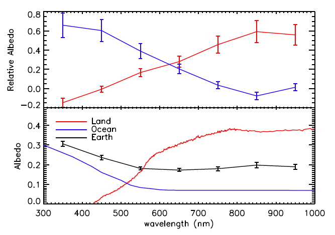
Fig. 1: Top panel: Spectral components of the whole Earth, retrieved using a Principal Component Analysis applied to the EPOXI images after collapsing them to a single pixel.
Lower panel: Spectra of oceans and land on Earth from near-Earth sensing satellites, and the spectrum of the entire Earth (black line).
CREDIT: Tinetti et al. 2006a; McLinden et al. 1997
Fortunately, there is a possible way to infer the surface structure of an unresolved planet. As the planet rotates, its color will change: when oceans are facing us, the light reflected by the planet will be bluer, and when continents are facing us it will be redder. In principle, it should be possible to "invert" time-resolved color measurements of the light from an extrasolar planet, to infer the nature of its surface, and even to map it. Further information is available if we can observe extrasolar Earth-like worlds in the near infrared (wavelengths longer than about 750 nanometers). At near-infrared wavelengths, plants reflect light more strongly than in normal visible light. So by observing an extrasolar planet as it rotates, and using a range of wavelengths, we should be able to infer the existence of oceans, continents, and possibly even vegetation.
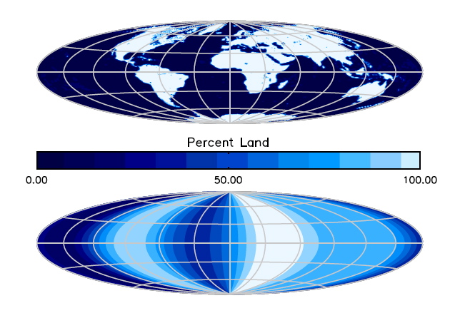
Fig. 2: Top panel: a normal map of Earth, made by earthlings who live here.
Lower panel: An "Alien Map" of Earth, made from the EPOXI data after collapsing it to a single pixel. This is the kind of map that we should be able to make for Earth-like extrasolar planets, to reveal that they have oceans and continents like our home world.
CREDIT: NASA/EPOXI/N.B. Cowan
EPOXI has recently put this method to the test, using our own Earth. EPOXI's Earth images, obtained from millions of miles distant, are the first remote, multi-wavelength, time-resolved, images of an Earth-like planet. The EPOCh team summed each image over all pixels, to further simulate how our Earth would appear to an alien observer, viewing us from a vantage point in another planetary system. The team - led by Nick Cowan at the University of Washington - then inverted these data to make "Alien Maps" of our home world. Inversion of the rotational data, and application of a Principal Component Analysis, shows the existence of two dominant spectra - hence two surface types - on Earth. Figure 1 shows these spectra, and compares them to actual spectra of oceans and land on Earth from near-Earth satellite measurements. From this comparison, we conclude that the alien observer would infer accurate spectra for Earth's dominant topography types and could tell that Earth had oceans and continents! Using these spectra in the inversion, the alien observer would be able to make a crude map showing how Earth's oceans and continents were distributed. This "Alien Map of an Ocean-Bearing World" is shown in Figure 2, in comparison to Earth's actual map. The alien map smears the continents in latitude, because it relies on rotational variations seen in the ecliptic plane (nearly coincident with Earth's equatorial plane). From this vantage point latitude variations in Earth's topography are not modulated as Earth rotates, so they can't be disentangled using the inversion technique. But observers viewing from a different angle might be able to infer latitude structure on Earth.
Whether or not intelligent observers on other planets have actually mapped our Earth in this fashion is purely speculative. But a solid conclusion from this study is that we can do the same type of mapping for extrasolar Earth-like planets, when they are eventually found and imaged by missions like the Terrestrial Planet Finder. By inverting their rotational light curves, we can expect to infer the existence of oceans. This conclusion is very significant because the presence of large bodies of liquid water is believed to be a highly favorable environment for the development of life. A paper documenting this new EPOXI study, entitled "Alien Maps of an Ocean-Bearing World", by N. Cowan et al., has been submitted to the Astrophysical Journal.
- EPOXI EPO Lead: Dr. Lori Feaga
- Webmaster: Elizabeth Warner
- Last Updated: Fri 02/23/18
- Web Accessibility
- + Contact NASA